To make your visit go as smoothly as possible in the fall and winter, let’s start with some useful information!
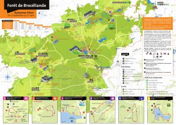
Perhaps you already know, the forest is 90% private and in the south, 5000 hectares are inaccessible (it is the military field of Saint-Cyr Coëtquidan). We therefore advise you to prepare your walk well, especially in autumn and winter, as this is the period of logging and hunting. You will find on this page the map of the forest which will be very useful from September 20 to March 31. You can find it free of charge in the tourist offices of Destination Brocéliande.
In addition, you can download the practical guide and calendar of days hunted in the state forest, based on the ONF calendar.
And find the Fall-Winter PMR map ICI

